
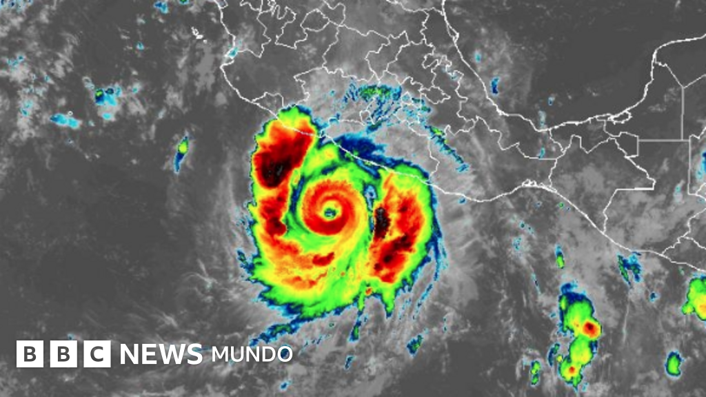
Hurricane Polo Weakens After Rapid Intensification
In a remarkable turn of events, Hurricane Polo has lost some of its strength after rapidly becoming one of the fastest intensifying storms on record in the Pacific. This article explores the evolution of Polo’s intensity, its current status, and the implications for the regions in its path.
Current Status of Hurricane Polo
As of Wednesday, Hurricane Polo had weakened but still boasted maximum sustained winds of 240 km/h, with gusts reaching 305 km/h, placing it at a strong Category 4 on the Saffir-Simpson scale. The storm had briefly reached Category 5 on Tuesday, a rare feat achieved in a remarkably short time frame.
The Mexican National Meteorological Service (SMN) reported that Polo was located approximately 270 km south of Zihuatanejo, Guerrero, and was moving slowly towards the northwest. While it is projected to travel parallel to Mexico’s Pacific coast, the storm may still generate heavy rainfall and pose risks of flooding and landslides in Guerrero, Michoacán, Colima, and Jalisco.
In response to the impending weather conditions, the SMN urged residents of the aforementioned states to exercise caution due to expected rain, strong winds, and high surf. Authorities have encouraged locals to heed recommendations from the National Civil Protection System.
Future Trajectory of the Storm
It remains uncertain whether Polo will veer away from the Baja California Peninsula this coming weekend. The National Hurricane Center (NHC) forecast suggests that a sharp turn towards the northwest may take place later today, followed by a general west-northwest movement into the weekend.
The NHC indicated that Polo’s center would likely remain offshore near southwest Mexico for the next couple of days, with an emphasis on staying out at sea. As a precautionary measure, schools in the coastal municipalities of Guerrero and Michoacán have canceled classes for Tuesday and Wednesday.
Rapid Intensification Insights
Meteorologists have noted that Hurricane Polo intensified from a tropical storm to a Category 5 hurricane in just 36 hours, ranking it among the three quickest storms to achieve such strength, alongside Hurricanes Otis (2023) and Patricia (2015). This rapid intensification is being fueled by the ongoing El Niño phenomenon, which climatologists have warned is projected to be one of the strongest on record.
On September 19, sea surface temperatures in a critical area of the eastern-central Pacific hit 3.05°C above average, surpassing the previous record of 3.02°C set during the 2015 El Niño. While other indicators of this “Super El Niño” haven’t yet reached unprecedented levels, this situation may change as we approach the end of the year.
The Broader Implications of El Niño
Every El Niño event is unique, leading to varying impacts on global weather patterns. Although this year’s strong El Niño may not yield extraordinary effects on climate, scientists are already observing anticipated changes worldwide.
Adam Scaife, head of long-term forecasting at the UK’s Meteorological Office, noted that while the magnitude of this El Niño is significant, its proportional impacts are still under evaluation. Historically, this phenomenon enhances the likelihood of storms and flooding in some areas while causing droughts and wildfires in others.
Typically, El Niño leads to a decrease in hurricane activity in the Atlantic due to shifts in upper-atmospheric wind patterns. Notably, 2026 has experienced no hurricanes in the Atlantic, marking a new record for the latest date without such formations since satellite monitoring began.
Conversely, the Pacific has seen an increase in storm and hurricane activity, with Hawaii and parts of Southeast Asia being the most affected this year. Further effects, which are already being felt, include heightened flood risks in coastal regions of Ecuador, Peru, and the southern United States, alongside increased threats of drought and wildfires in Brazil, Australia, and Indonesia.
These weather-related phenomena could have significant ramifications for crop yields, food security, and economies across the globe.
Conclusion
Hurricane Polo’s rapid intensification into a Category 5 storm highlights the dynamic nature of weather patterns influenced by phenomena like El Niño. As anticipated changes unfold, communities must remain vigilant and prepared for potential impacts from severe weather.
- Hurricane Polo weakened after reaching Category 5 status.
- The storm is expected to remain offshore while impacting several Mexican states with heavy rainfall.
- Polo intensified rapidly due to strong El Niño conditions.
- This year’s El Niño is predicted to significantly affect global weather patterns.